![](/images/other/stat-length.png)
![Trail Mountain bike Les Épesses - Des Epesses à Réaumur - Photo](https://media.geolcdn.com/t/1900/400/ext.pjpeg?maxdim=2&url=https%3A%2F%2Fstatic1.geolcdn.com%2Fsiteimages%2Fupload%2Ffiles%2F1524743154velo.jpg)
Des Epesses à Réaumur
tracegps
User
![Length](/images/other/stat-length.png)
Length
59 km
![Max alt](https://static1.geolcdn.com/siteimages/upload/files/1508320355ic_sort_altitude_max_24dp.png)
Max alt
251 m
![Uphill gradient](https://static1.geolcdn.com/siteimages/upload/files/1508320355ic_sort_den_pos_24dp.png)
Uphill gradient
747 m
![Km-Effort](/images/other/stat-length.png)
Km-Effort
69 km
![Min alt](https://static1.geolcdn.com/siteimages/upload/files/1508320355ic_sort_altitude_min_24dp.png)
Min alt
105 m
![Downhill gradient](https://static1.geolcdn.com/siteimages/upload/files/1508320355ic_sort_den_neg_24dp.png)
Downhill gradient
792 m
![Boucle](https://static1.geolcdn.com/siteimages/upload/files/16400158638029165_repeat_loop_refresh_sync_direction_icon.png)
Boucle
No
Creation date :
2014-12-10 00:00:00.0
Updated on :
2014-12-10 00:00:00.0
![Mountain bike](https://static1.geolcdn.com/sitytour/trail-icons/202.png)
4h00
Difficulty : Very difficult
![Scan this QR Code to open this trail in the SityTrail application](https://capi.geolives.com/qq0zvz2zws4bq2lad0pu/sitytour/trails/100776/qr.png?size=200)
FREE GPS app for hiking
About
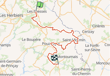
Trail Mountain bike of 59 km to be discovered at Pays de la Loire, Vendée, Les Épesses. This trail is proposed by tracegps.
Description
Départ : Parking du grand parc du Puy du Fou Niveau : Très Difficile - accessible VTC Curiosités : Point culminant de la Vendée à St-Michel, Mont Mercure, Bois des Jaries, Château de la Flocellière.
Positioning
Country:
France
Region :
Pays de la Loire
Department/Province :
Vendée
Municipality :
Les Épesses
Location:
Unknown
Start:(Dec)
Start:(UTM)
659759 ; 5194328 (30T) N.
Comments
Trails nearby
![Trail Mountain bike Les Épesses - Mallievre - St Malo du Bois - Photo](https://media.geolcdn.com/t/375/260/ext.jpg?maxdim=2&url=https%3A%2F%2Fstatic1.geolcdn.com%2Fsiteimages%2Fupload%2Ffiles%2F1524743154velo.jpg)
![Mountain bike Mountain bike](https://static1.geolcdn.com/sitytour/trail-icons/202.png)
Mallievre - St Malo du Bois
Mountain bike
Very difficult
(1)
Les Épesses,
Pays de la Loire,
Vendée,
France
![](/images/other/stat-length.png)
30 km | 36 km-effort
2h 15min
![](https://static1.geolcdn.com/siteimages/upload/files/16400158638029165_repeat_loop_refresh_sync_direction_icon.png)
Yes
![Trail Mountain bike Saint-Mars-la-Réorthe - St Michel Mont Mercure - Photo](https://media.geolcdn.com/t/375/260/ext.jpg?maxdim=2&url=https%3A%2F%2Fservices.sitytrail.com%2FGeolivesWS%2FDownloadMedia.ashx%3FTrailID%3D101510%26Media%3D1615_6.jpg)
![Mountain bike Mountain bike](https://static1.geolcdn.com/sitytour/trail-icons/202.png)
St Michel Mont Mercure
Mountain bike
Very difficult
Saint-Mars-la-Réorthe,
Pays de la Loire,
Vendée,
France
![](/images/other/stat-length.png)
21 km | 26 km-effort
2h 0min
![](https://static1.geolcdn.com/siteimages/upload/files/16400158638029165_repeat_loop_refresh_sync_direction_icon.png)
Yes
![Trail Walking Treize-Vents - rando les treize cents 18km - Photo](https://media.geolcdn.com/t/375/260/7348d043-cdab-4698-91ff-220ba9aac84e.jpg&format=jpg&maxdim=2)
![Walking Walking](https://static1.geolcdn.com/sitytour/trail-icons/101.png)
rando les treize cents 18km
Walking
Very difficult
Treize-Vents,
Pays de la Loire,
Vendée,
France
![](/images/other/stat-length.png)
19.6 km | 24 km-effort
4h 47min
![](https://static1.geolcdn.com/siteimages/upload/files/16400158638029165_repeat_loop_refresh_sync_direction_icon.png)
No
![Trail Walking Treize-Vents - treize vents Mallievre - Photo](https://media.geolcdn.com/t/375/260/51e2291d-e12b-49f3-948f-44d737b92c39.jpg&format=jpg&maxdim=2)
![Walking Walking](https://static1.geolcdn.com/sitytour/trail-icons/101.png)
treize vents Mallievre
Walking
Very difficult
Treize-Vents,
Pays de la Loire,
Vendée,
France
![](/images/other/stat-length.png)
18.1 km | 23 km-effort
4h 51min
![](https://static1.geolcdn.com/siteimages/upload/files/16400158638029165_repeat_loop_refresh_sync_direction_icon.png)
No
![Trail On foot Chanverrie - Circuit pedestre de Chambretaud - Photo](https://media.geolcdn.com/t/375/260/ext.jpg?maxdim=2&url=https%3A%2F%2Fstatic1.geolcdn.com%2Fsiteimages%2Fupload%2Ffiles%2F1545311037marcheuse_200dpi.jpg)
![On foot On foot](https://static1.geolcdn.com/sitytour/trail-icons/100.png)
Circuit pedestre de Chambretaud
On foot
Easy
Chanverrie,
Pays de la Loire,
Vendée,
France
![](/images/other/stat-length.png)
3.2 km | 3.8 km-effort
52min
![](https://static1.geolcdn.com/siteimages/upload/files/16400158638029165_repeat_loop_refresh_sync_direction_icon.png)
No
![Trail Walking Treize-Vents - Treize vents Mallièvre,18km - Photo](https://media.geolcdn.com/t/375/260/ext.jpg?maxdim=2&url=https%3A%2F%2Fstatic1.geolcdn.com%2Fsiteimages%2Fupload%2Ffiles%2F1553511878bg_sport_marche.png)
![Walking Walking](https://static1.geolcdn.com/sitytour/trail-icons/101.png)
Treize vents Mallièvre,18km
Walking
Very difficult
Treize-Vents,
Pays de la Loire,
Vendée,
France
![](/images/other/stat-length.png)
17.9 km | 22 km-effort
5h 3min
![](https://static1.geolcdn.com/siteimages/upload/files/16400158638029165_repeat_loop_refresh_sync_direction_icon.png)
Yes
![Trail Quad Les Épesses - Treize vents les epesses - Photo](https://media.geolcdn.com/t/375/260/ext.jpg?maxdim=2&url=https%3A%2F%2Fstatic1.geolcdn.com%2Fsiteimages%2Fupload%2Ffiles%2F15247431544x4.jpg)
![Quad Quad](https://static1.geolcdn.com/sitytour/trail-icons/404.png)
Treize vents les epesses
Quad
Les Épesses,
Pays de la Loire,
Vendée,
France
![](/images/other/stat-length.png)
18.7 km | 23 km-effort
55min
![](https://static1.geolcdn.com/siteimages/upload/files/16400158638029165_repeat_loop_refresh_sync_direction_icon.png)
No
![Trail Walking Les Épesses - Les Epesses - Photo](https://media.geolcdn.com/t/375/260/ext.jpg?maxdim=2&url=https%3A%2F%2Fstatic1.geolcdn.com%2Fsiteimages%2Fupload%2Ffiles%2F1553511878bg_sport_marche.png)
![Walking Walking](https://static1.geolcdn.com/sitytour/trail-icons/101.png)
Les Epesses
Walking
Medium
Les Épesses,
Pays de la Loire,
Vendée,
France
![](/images/other/stat-length.png)
17.7 km | 22 km-effort
4h 50min
![](https://static1.geolcdn.com/siteimages/upload/files/16400158638029165_repeat_loop_refresh_sync_direction_icon.png)
Yes
![Trail Walking Treize-Vents - Mallièvre Sentier des jonquilles - Photo](https://media.geolcdn.com/t/375/260/ext.jpg?maxdim=2&url=https%3A%2F%2Fstatic1.geolcdn.com%2Fsiteimages%2Fupload%2Ffiles%2F1553511878bg_sport_marche.png)
![Walking Walking](https://static1.geolcdn.com/sitytour/trail-icons/101.png)
Mallièvre Sentier des jonquilles
Walking
Medium
Treize-Vents,
Pays de la Loire,
Vendée,
France
![](/images/other/stat-length.png)
9.8 km | 11.6 km-effort
2h 40min
![](https://static1.geolcdn.com/siteimages/upload/files/16400158638029165_repeat_loop_refresh_sync_direction_icon.png)
Yes